
I demand a lot from a trail. I want it to make me ache, in my muscles, and somewhere deeper. I could claim I’m out for the fresh air, a snatch of birdsong. But I want a summit, a panorama, a destination. I want escape. I want encounter.
Maybe I want too much.
The truth is, I don’t always know what I want. So, I pick a trail and walk out into the world, see what I get. Most trailheads around Boulder roll out through sage meadows and low open woods, up into foothill forests, tangled gulches, broken light through the canopy, the press of trunks threading toward the promise of something more. Sometimes that promise opens early. The trunks fall back, the canopy breaks, and I find myself in a park, an expansive clearing hemmed by trees. There is grass, there is sky, and there is me. I am struck by it, by the sudden rush of space. I welcome it. And it brings me pause.
Without knowing it, this is exactly what I want.
In the foothills of the Elkhorn Mountains, Boulder Park is everything a park should be: Wide but not too wide; Open but not empty; freedom after the uphill grunt that got me there; an absence. It’s accessed easily from Boulder by three distinct, converging routes.
From McCarty Creek
Distance: 3.0 miles one-way, links to other routes
Net Elevation Gain: 1,100 feet
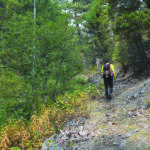
Once a wagon road between Boulder and the remote Elkhorn mining camp, today’s jeep road up McCarty Creek has lost much of its history but retains a rough-riding heart. Cross the cattleguard to begin hiking north on the narrow dirt road between fence lines. The first mile dips and winds along the jeep track toward wooded ridges through meadows of sage and snowberry, pockets of aspen and fir. The gentle climb steepens toward a forest ascent into Boulder Park. It’s the closest route to Boulder, and the longest.
The initial track follows an easement across private land. A crossing over the trickle of McCarty Creek at 0.5 miles curves right through a gate. A second shallow crossing leads to progressively wetter trail. If it’s bumbling diversion I want, I’ve found it. Toward the one-mile mark, large puddles and mud traps test foot placement as half-sunken boulders force the road to bank.
At 1.25 miles, the track snakes through a large meadow under the powerline. Through forest just shy of 2 miles, it tackles a steep pitch between low walls of sand. Boulders the size of small beasts slump into the narrow trough. The short scramble spits me out through lenses of aspen. Climbing steadily toward the three-mile mark, the trail tops a final, tank-sized boulder submerged before a water trough.
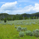
I’m ready for some kind of arrival. It comes, but it’s gradual. I want to feel uplifted as I crest into Boulder Park. Instead, I’m tugged by tension. Firs open slowly into a wide grassy meadow crowded with sage. It’s flat. It’s relief from the climb, and I want the relief. But I love the climb. I need plateaus; but I thrive on striving. I refuse to trade one for the other.
It’s my own inner contradiction, and that’s what I find in Boulder Park.
From Turnley Meadows
Distance: 2.0 miles one-way, links to other routes
Net Elevation Gain: About 600 feet
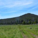
Of the three routes into Boulder Park, the trail from Turnley Meadows feels the steepest while revealing a landscape in transition on a grand scale.
Since the late 1990s, an unprecedented infestation of mountain pine beetle has ravaged pine forests across western North America, including more than 6 million acres across Montana. Declining infestation cannot erase the altered habitat, the burden of deadfall, or the legions of standing dead trees yet to drop.
But death need not dominate. The dense bridging and bowing and banding of trunks sculpt a fresh take on forest cover. An elk study released by Montana Fish, Wildlife, and Parks in 2019 found that canopy cover in dead lodgepole pine forests of the Elkhorn Range still offers meaningful security for big game.
I am not big game. But I still have to negotiate the terrain.
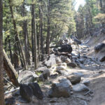
From the trailhead the gulch closes in quickly. The climb is steep, rocky, sandy, rutted, banking, and kinked, with numerous bypasses around extra-rocky obstacles. Tree snags overhang rubble strewn across the trail like fists or skulls or shields. It’s a battleground out there. But the jeep track is clear.
After a mile and a half, the trail rolls, opens slowly, passes through a gate, and approaches the edge of Boulder Park. It’s a wide, grassy bowl rimmed by low ridges. I shed the shelter of trunks to step into a space that may expose me, comfort me, swallow me. About a half mile across, it feels big and I am right there in it, I am smaller than I think. Is it something primitive, my inner dive for cover? I want security. To know that I am safe, I am whole, I am who I believe myself to be.
But I am also curious, so I enter the clearing, walk my line toward the far side.
From Twentyone Gulch
Distance: 1.75 miles one-way, links to other routes
Net Elevation Gain: About 600 feet
The trail to Boulder Park from Twentyone Gulch is the only non-motorized route, and the shortest to the summit.
The first half-mile climbs gently up a wet, narrow gulch into a sage meadow with high slopes. Tall grass may obscure the footpath early in the season;
the left creek bank through the meadow picks up a defined trail under the firs.
Once in the woods, low talus stringers parallel the route. Trees rise out of the gulch’s rubble shoulder. I come lugging my oversized expectations: Blitz my body! Stun my soul! Without views, I find delight in the damp shade of fallen logs: green-flowered wintergreen, one-sided wintergreen, bolete mushrooms. The trail climbs through shade and skirts left around a large pile of boulders at one mile. In a quarter mile more, a gate: The trail flattens through aspen scrub and deadfall, trending right into Boulder Park.
I have been here before. I could cross Boulder Park on a faint path – keep right to meet the trail from Turnley Meadows, keep left to meet the trail from McCarty Creek. I could link left toward Turkey Track, climb a mile more up through forest to Half Moon Park.
Some days, it’s enough just to crest, to stand my back to the forest and gaze out across the grass. Some days, I swallow that space, a deep breath that ropes me to the spot, flings my gut to the distant trees. I want a bridge. I am the bridge.
Once, after descending from Boulder Park, I shared a sandwich with my toddler on my open tailgate. Early September, late afternoon, purple shadow, clear light. An elk bugled. I looked at my daughter, she looked at me, eyes wide but knowing, wanting.
How to get to the trails
•To McCarty Creek trailhead: Take East Fourth Avenue 0.5 miles, curving right onto Muskrat Lane. In another 0.7 miles cross Upper Valley Road at a yield sign. Continue straight onto McCarty Creek Road. After 0.5 miles cross a cattle guard and curve left. Proceed 1.8 miles to a dead end with a large parking area and turn-around. Ruts toward the end may not be suitable for two-wheel drive or a low-clearance vehicle. To hike, cross the cattle guard from the parking area and follow the jeep road. To Twentyone Gulch and Turnley Meadows trailheads: Follow Highway 69 south for 7 miles. Turn left at the Elkhorn sign onto White Bridge Lane. Cross the Boulder River and continue right for 3 miles, keeping left at your first junction onto Elkhorn Road then left again to stay on Elkhorn Road.
•Twentyone Gulch: Drive 6 miles, cross a bridge, and hook immediately left down a brief hill to the trailhead. •Turnley Meadows: Drive 7.5 miles to an unsigned left turn, (the second left past the Twentyone Gulch trailhead). Two-wheel drive is not recommended from here. Cross an immediate shallow creek then turn right. Proceed 1 mile to the trailhead on your left (sign says “McCarty-Rawhide”). To avoid the creek crossing in an approach that may be managed by some in two-wheel drive, park instead at the first left past the Twentyone Gulch trailhead. Public passage across this private parcel is currently and generously permitted by the landowner. Proceed 1.5 miles to the trailhead.
Vaia Errett is one of seven volunteers serving on the Jefferson County Parks, Trails and Recreation Commission, an advisory group to the Board of Commissioners. Send comments to ptrc@jeffersoncounty-mt.gov or visit www.jeffersoncounty-mt.gov/trails.html

