
If you live in Jefferson County and want to ski somewhere with ski lifts, you’ll have to drive for a while: Great Divide Ski Area, between Helena and Lincoln, is about 40 minutes from Montana City and slightly more than an hour from Boulder; Discovery Ski Area west of Anaconda is about 90 minutes from Whitehall and nearly two hours from Boulder—Bridger Bowl is just as far, and Big Sky even farther.
But travel back in time 90 years and you wouldn’t have to leave the county—or even the Boulder area—to be towed by a lift to the top of a ski run and cruise back down to the bottom on natural snow. In the early and mid-20th century, multiple rope tows at small ski areas in Jefferson County ferried skiers to the tops of runs that long ago were abandoned and subsequently disappeared from the landscape, erased by natural and human intervention, surviving only in the memories of the few remaining people who made turns there.
Boulder Hill
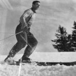
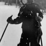
Trenna Lee Hollaway Scoffield was born in 1935 and lived in Boulder for the first six years of her life, through the first grade. Scoffield, now 86, said in a phone call from her winter home in Yuma, Arizona, last November that she remembered skiing the Boulder Hill ski run as a child with her father, Don Hollaway, and her mother, Esther.
“I remember it well,” she said, pegging the time somewhere around the late ’30s. “It was a pretty good run. I don’t know when it stopped, I don’t know when it started.”
Scoffield distinctly remembered learning to ski on the Boulder Hill before the attack on Pearl Harbor on Dec. 7, 1941, drew the U.S. into World War Two, leading Don Hollaway to move the family away from Boulder for work. The family eventually settled in Townsend when Scoffield was in the fourth grade, and she still lives on her farm between there and Toston in the summer.
“We left the state because of the war before I became any good at skiing, but my dad was pretty good. To start me off, he would just put me between his legs in front of him. But then he taught me how to snowplow,” she recalled. “The old ski bindings, you know, were not very safe. But I had regular little ski boots and poles. My parents had very good looking ski clothes, probably from Jack Frost, Van Raalte Woolly Wyns—there was a salesman that went around to your home.”
The Boulder Hill ski run, she added, “would have long ago disappeared.”
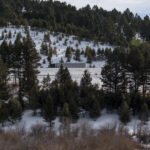
According to Boulder resident Sam Samson, 82, the Boulder Hill ski run ran roughly perpendicular to present-day Interstate 15, just over the top of the Boulder Hill to the north, as northbound traffic makes its first right-hand curve, following an initial left-hander after cresting the hill. Historical maps from the U.S. Geological Survey, coupled with historical aerial imagery from before the interstate was constructed, show a ski run cut down along the crest of a northwest-facing hill directly across from the original railroad section house, where today there’s an empty lot on the frontage road.
Samson, a fifth-generation southwest Montanan, former Jefferson County Commissioner and retired longtime teacher at Jefferson High School, set out to write a book in the mid 1980s about old Montana ski areas. Samson grew up in Helena, and his parents frequently skied the Boulder Hill and in the Elkhorn Mountains, he said. He’s skied all over and he still does. During his research for the book, Samson said, former County Sheriff George Paradis took him up the Boulder Hill and showed him the location of the old ski run. Paradis gave Samson the old wooden skis he used to make turns on the Boulder Hill, and they now adorn Samson’s house a few miles outside Boulder.
Samson didn’t complete his book, but he handed off his notes to a man who did: Stan Cohen wrote “Downhill in Montana,” a pictorial history of skiing in Montana. The Heritage Center in Boulder has the book on-hand.
Based in large part on Samson’s research, the passage in the book about the Boulder Hill describes the ski area as being a 1,500-foot ski run with a 1,200-foot rope tow powered by “an old Durant automobile,” and built in the late ’30s. It cost 50 cents to ski for the day.
A Jan. 25, 1940, story in the Big Timber Pioneer newspaper stated that “A new power tow line has been installed with 250 more yards rope than last year” at the Boulder Hill. That story placed the ski run “just east of the airways beacon on top of the hill.”
Elkhorn
Scoffield, Samson and “Downhill in Montana” also mention a ski area in Elkhorn around the same period—the years leading up to World War Two—but the location of that ski area is less clear.
The book describes ski runs in “Alice Basin … at the base of Elkhorn Peak.” The ski run, it said, was five-eights of a mile wide and 1.25 miles long, and at one point featured two rope tows: A lighted 2,000-foot rope tow and an unlit 1,000-foot tow. The ski area closed after the 1941 winter, according to the book.
That account drew nearly word-for-word from an essay in the 1945 American Ski Annual, authored by a group of Helena skiers that included Samson’s parents, who described hiking up Elkhorn Peak from the Elkhorn ghost town, skiing an “Alice Basin” down to the old Iron Mine site on the northwest flank of the mountain, reascending the peak and then skiing back to Elkhorn through the Louise and C&D mine sites.
Historical and modern maps don’t show anywhere formally named “Alice Basin” in the area of Elkhorn Peak. Some longtime area residents recalled that the ski area was possibly beneath the white cliffs on the south face of Elkhorn Peak, or around the Louise Mine site itself.
Regardless of exactly where the site was located, before the United States’ involvement in World War Two, Elkhorn had a brief shot at a rebirth as a ski town. A letter from Virgil Newman, dated July 17, 1940, and typed on his brand-new Elkhorn Resort Co. letterhead, implored a man named John to sell him a rope tow for his ski area above Elkhorn, which he said already featured an old tow sold to him by the Boulder Athletic Club—the proprietors of the Boulder Hill ski run.
“I know the skiing is here, what I need is the skiers,” Newman wrote in the letter, which is featured in Cohen’s book. “Can drop them 3,000 vertical feet in 2 miles if they can take it, or they can drag it out to 6. All over open country, then breaking into scattered timber.”
“[T]he headache of short runs, and not steep enough are over,” he wrote.
The ski area closed the year after that letter.
Z Bar T
It would be another 18 years before a skier could ride a lift in Jefferson County—although rope tows were spinning on ski runs atop Pipestone Pass, barely outside the county, from the 1949–50 season through the ’53–’54 season.
A few miles east on state Route 2, then U.S. Highway 10, the Z Bar T ski area opened on Toll Mountain in 1959. According to Cohen, the ski area was named after the cattle brand of the Wilson family, who owned the operation.
“The family built the entire area themselves including the chalet, ski patrol A-frame, ticket booth, the rope tow a Poma lift and a T-bar,” Cohen wrote. The lifts served about 800 vertical feet of skiing across multiple runs named after Native American tribes.
Despite plans to put in an aerial chairlift, the Z Bar T closed in 1976 after years of poor snow conditions and financial difficulty. The chalet is now a private residence, and the ski runs, ticket booth, patrol hut and lift towers—all on private land on the north side of the almost perfectly conical Toll Mountain—are still barely visible nearly 50 years later.
It’s been 46 years since anyone rode a ski lift in Jefferson County—the lifts at Z Bar T being the last to turn. Since then, skiers have done it the same way they did before the lifts were there: They have to earn their turns.

