
Why climb to the top of a mountain? Maybe that’s what the miners of Elkhorn asked as they tunneled dark shafts beneath the highest points of the Elkhorn Range, forging lives out of fever, for fortune. Silver mining began in the 1870s, peaked through the turn of that century, then receded into history. The route to the summits still rises from Elkhorn through forest to dwindle and die above treeline.
What endures is the stark statement of a mountain. No apologies, no invitations. Just earth, buckled in battle with sky.
Why climb to the top? To meet the mountain on its own terms. Fire molded and raised the rock. Air and water will take it down again. The ore bodies are tapped. The outcrops have cooled their skin. But fever lingers, a turmoil of nameless desires bubbling in our bones. We’re not that different, you and I, miners and mountain. Match your flesh against those bared spines, every glittering mineral fleck and ash mote pressed into heights announced at a distance by the rib of white marble just below Elkhorn Peak, only 33 feet lower than its near neighbor, Crow Peak, at 9,414 feet.
From Ghost Town to Ghost Forest
The preserved facades of Elkhorn make up Montana’s smallest state park. Drive through the old mining camp to its high end where the road hooks right above town. Consider parking here in two-wheel drive. Just ahead, a large sign marks a T-junction. The right branch leads to the cemetery, where children’s gravestones chronicle an 1889 diphtheria epidemic, a reminder that there is no contract of exchange here. We may give ourselves up to the mountain. The mountain owes us nothing.
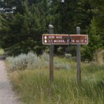
To hike the peaks, take the left branch up a short hill toward Muskrat Trail and the Iron Mine. Park just past the giant red water tank, relic of the Northern Pacific Railroad. Another sign directs you right, toward Muskrat Trail.
This is Diego Town Road, also called the Iron Mine Road. While hoist and stamp prised riches by the ton from the Elkhorn Mine, one of the district’s largest producers, millions of years of folding and faulting, eruption and intrusion, accumulated metals in additional ore bodies. The highest number and variety of mineral deposits are found within a 2-mile radius of Elkhorn.
The road toward the peaks bypasses old shafts abandoned to forest. It’s a steep climb with loose, rocky footing, but it carries you from a footprint of extraction through zones progressively more remote.
Get your first glimpse of Elkhorn Peak within a quarter mile. Break into a meadow with skyline views before a trail sign guides you back into trees. At 0.75 miles, fork left at a prominent “Y” junction. Be prepared for wet trail. At about 1.75 miles, a narrow park on your left spills down wooded ridges into the Boulder Valley.
With miner’s cabins subsiding into foothills below you, this forest offers up its own skeletons. The silvery trunks of whitebark pine signal higher elevation, and a bare-bones vulnerability: Outbreaks of mountain pine beetle and white pine blister rust have decimated whitebark pine populations across most of western North America. Almost three miles up Diego Town Road, the ghost trees crook naked limbs across a trail forking right. Branch here for the summits.
Signage on a padlocked gate permits non-motorized access across private property. The trail narrows as it climbs half a mile to Windy Point.
From plateau to peak, to peak
Gaze up at Elkhorn Peak from the Boulder Valley. At a distance, the white banner of Windy Point just below the summit looks like snow, or cloud, or fog. But walk that high horizon and the mountain flashes you proof that it is made, as you are, of more substance.
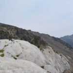
Step out of forest. Skirt the talus of Elkhorn, the summit you’re striving to crest. Veer instead over windswept hummocks to the gap where bare grass cups the sky. Top out onto a plateau of white – not snow, not cloud, not fog: Marble.
A destination in its own right, Windy Point forms the rim of a cirque, a giant hollow imprinted on the mountain’s flank by the weight of a glacier once squatting on Elkhorn Peak. The marble – limestone altered by heat – is unexpected between volcanic outcrops. It distinguishes the mountain, like scars we all carry. Exposed when the ice retreated, the white rock of Windy Point is a launching pad for the final half-mile climb to Elkhorn Peak.
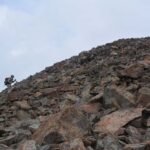
You’re high enough now that water falls only from the sky. Even the trees start giving up. There are cairns – low stacks of rock that mark the trail – but these route markers are swallowed against the summit’s wall of talus. To find the cairns, face the high peak, then angle left toward the lesser knob. A trail whispers up blocky rubble to desert you in the shadow of the hunchback.
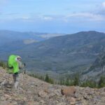
It’s earth and ether from here, muscle and lung. Catch your breath. It’s the only thing left that’s yours. There are views: Elkhorn. The Boulder Valley. The Bull Mountains. The Boulder Mountains. Climb as ridges roll out to clouds, until all earth is beneath you. When you can go no higher, there is nothing left to name.
Unless you choose to hoof it over to Crow Peak. You can go higher. Only thirty-three feet higher, but a mile and a half more beyond Elkhorn Peak.
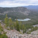
Wade down 500 feet in elevation through more talus. There is no trail. Brave the low thatch of trees across the saddle between summits. Watch for the occasional mountain goat, shaggy angel of impossible slopes. The earth sheers down into cirques you cannot see. Clamber to the edge. Cliffs bottom into the bowls of Hidden Lake, Tizer Lakes, and Glenwood Lake, reflecting cloud-swept heights you’ll never tread.
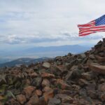
Yet the ground rises. It’s a steep scrabble up loose rock to plant your feet atop Crow Peak, highest point in the Elkhorn Range. The U.S. flag flaps here, alongside anything else you may find. If you’ve still got your breath, spend it now. Spill your small, human cry of, “Eureka!” The wind will lick it from your throat. Only now can you say you have met the mountain.
Vaia Errett is one of seven volunteers serving on the Jefferson County Parks, Trails and Recreation Commission, an advisory group to the Board of Commissioners. Send comments to ptrc@jeffersoncounty-mt.gov or visit www.jeffersoncounty-mt. gov/trails.html
How to get there
•Distance and Net Elevation Gain
3.5 miles one-way to Windy Point; 2,500 feet
4.0 miles one-way to Elkhorn Peak; 2,760 feet
5.5 miles one-way to Crow Peak; 2,790 feet
•Directions
From Main Street in Boulder follow Highway 69 south for 7 miles. Turn left at the Elkhorn sign onto White Bridge Lane. Cross the Boulder River and continue right on Lower Valley Road. Keep left at your first junction in 2 miles onto Elkhorn Road, then left again in another 0.8 miles at a sharp curve to stay on Elkhorn Road. Continue 8 miles to Elkhorn. Keep left through town. In two-wheel drive, consider parking above Elkhorn’s main strip where the road curves sharply right. Continue to a T-junction. Turn left and climb a short hill in a sturdy vehicle to park just past the old railroad water tank.

