
In the United States, political maps are typically represented as polygons red or blue – be they states, counties, or legislative districts: It’s first-past-the-post, and a plurality decides the winner.
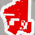
This species of analysis is called a choropleth map, a thematic color scheme that summarizes the attributes of the underlying data and, in the case of those you see on TV and the internet, who won a given race. For that purpose it’s fine — but too often, larger inferences seem to be made about geographies from those maps. If we look a bit closer at our county, maybe we can pull ourselves away a bit from the political partitioning with which we are currently inundated.
Let’s examine the voting precincts of our county and the results of the 2020 gubernatorial race between Democrat Mike Cooney, Republican Greg Gianforte, and Libertarian Lyman Bishop. (It’s worth noting that since that race, Montana has gone through a redistricting effort, so the precinct boundaries on these maps are now out of date.)
If we look at the results of that race in the typical choropleth style — the first map with this article — one might say that Jefferson County votes Republican. That’s not an incorrect statement insofar as who we helped send to the Governor’s office, but does it tell us about our neighbors and their political views with any depth?
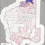
What if instead, we represent voters within a district as a distribution? Every dot on the second map equals two voters, and who they voted for. Red for Republican candidate, blue for the Democrat, and green for the Libertarian. This visualization is called a dot density map. The dots are randomly distributed within the precincts they are representing data for.
All of a sudden, the politics of our county look less absolute – and less simple. At first glance, one can see that large parts of our county are nearly void of permanent residents, while others have a high density of folks who vote. But beyond that, there’s more.
The fine folks of our county are currently besieged with messages from the financial machines of politics telling us all about the bad and the good, and what that does to us isn’t the point of this article. It’s certainly not to say that politics don’t matter to Jefferson County and its residents. They do.
But in the context of souls on the landscape, the undercurrent of political division flows atop a bedrock of community, and that’s worth remembering. Be they family, acquaintances, business owners, teachers, first responders – we aren’t a story that can be told by a solid color on some map. Whether the politics of November do or don’t go one’s way, hopefully we can see beyond the teams representing us and their maps to a political topography as varied as the basins and ranges of our own county. Impossible to display as a monolithic hue, we are neighbors.
Bret Lian lives in Clancy

