
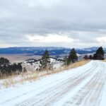
After more than two months without significant precipitation, snow — along with bitter cold — is finally arriving in Jefferson County this week.
The mountains need it.
Snowpacks on the county’s peaks and basins — and across much of the Mountain West — are at historically low levels, the result of unseasonably mild and dry weather since a pre-Halloween storm dumped about six inches of snow on the area.
In its monthly Montana Water Supply Outlook Report, released January 1, the USDA Natural Resources Conservation Service (NRCS) noted that “warm temperatures and lack of precipitation over the last couple months have resulted in a bleak start to the seasonal snowpack in Montana and northern Wyoming.”
A lack of snow curtails recreation activities such as skiing, skijoring, and snowmobiling, significant economic drivers for Montana in the winter. If sustained, it also can affect water supplies for the year ahead.
In most places across the region, the NRCS reported, the snowpack is currently about 30-60% of normal — and about 110 of 175 of its stations are reporting their lowest or second lowest snowpack on record.
Jefferson County’s stations are reporting record or near-record lows. The Tizer Basin station, located north of Elkhorn peak at an elevation of about 6,880, reported 9 inches of snow on Jan. 9. It has seen 3.9 inches of precipitation since the snow season began, a total 35% lower than the median precipitation in that period between 1991 and 2020, according to NRCS.
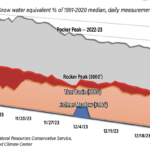
As a result, Tizer Basin’s snow water equivalent, which reflects how much water the snowpack actually contains, was just 42% of the 20-year median for that site. The Rocker Peak SNOTEL station, which sits at an elevation of about 8,000 feet near a saddle north of Basin, reported 14 inches of snow, yielding a snow water equivalent of 44% of its 20-year median. A year ago, the Rocker snowpack was 28 inches deep, 104% of median.
The Frohner Meadow station, located at 6,480 feet — lower than both Tizer and Rocker — at the top of the Lump Gulch drainage northwest of Jefferson City, appears to have been the hardest hit of the county’s observation sites. On Jan. 9, after lying essentially bare for weeks, Frohner reported just 2 inches of snow. Its snow water equivalent was 8% of the 1991-2020 median.
Overall, the snowpack across the Jefferson Basin — which includes central and southern Jefferson County — was 52% of its historical median at year-end, according to NRCS. The Upper Missouri Basin, which includes the northern part of the county, was at 33% of median, compared to 115% at the same time a year ago.
Of course, it’s still early in the snow season. Water Supply Specialist Eric Larson noted in the NRCS report that “It would take a major change in what the last couple months brought for weather, but the current deficit could be recovered in a couple large storms.”
Larson added: “The mountain snowpack in Montana typically peaks in April or early May, so there is still time to recover. Spring weather can be active in Montana, and in recent years water supply conditions have rebounded from record low April snowpack conditions due to well above normal spring precipitation.”
Indeed, this winter’s snowpack pattern is similar to that of two years ago, when a very dry autumn and early winter left the Tizer Basin at around 40% of the median snow water equivalent until January, when heavier snows finally arrived. Frohner Meadow’s snowpack was at about 80% in early January, 2022, before returning to historical norms later in the winter.

