
Below Elkhorn, Queen Gulch leads to destinations hidden by high country as it carves the foothold of Crow Peak. The steep jeep road along the creek may frustrate your footing before it ends in a cirque southeast of the summit. But the climb caches backcountry payoff: the lurk of cutthroat in Leslie Lake or Glenwood Lake, the lure of paydirt at the Elkhorn Skyline Mine, or the climax of a back-route beeline to Crow Peak, highest point in the Elkhorn Mountains at 9,414 feet, concealed from view until the crowning moment.
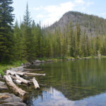
Leslie Lake
Your first steps into Queen Gulch carry you across its creek. Expect to walk a log or hop rocks a few times more in the first mile as the jeep road catches the flow from lesser gullies draining the southern flank of Crow Peak.
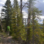
Across the creek, turn left past an unfinished private cabin. The trail wastes no time shuttling you up the initial rocky climb. Flanks of fir draped with lichen ease your first footfalls on loose stone.
Pass through the remnants of a gate in a rail fence then level into a clearing in a quarter mile as Hobo Gulch sneaks in on your left. On your right, a faint track leads up to Radersburg Pass. Known through local lore as Lupienville after a mining heyday resident and the wagon stop named for him, the clearing pinches quickly back into trees.
Meet the seep of Dubois Gulch before its fingers steal into Queen Gulch. For the next half mile, weave through puddled stretches where upstream flow spills down the trail from shallow crossings. Watch your footing as you caper over wet rocks, but peek off-trail to spy glittering ribbons cascading through shade.
Cross a cattleguard at about 0.7 miles as the rocky route steepens. Just before the one-mile mark, hook right then left as Dubois Gulch merges without fanfare considering its watery prelude. Like cobblestone with no mortar or mud to bind it, the road challenges your ambition for loftier locales. Press on to claim your summit.
A mile farther, your parting with Queen Gulch goes unnoticed. Before the 2.5-mile mark, watch for the sign to Leslie Lake through a meadow junction. Branch left off the jeep road onto a track ablaze by mid-summer with Indian paintbrush, death camas, buttercups, and lupine.
The track climbs a straight run. In a quarter mile, hook right to rejoin Queen Gulch from above as it drains Leslie Lake. Level at first, the narrow trail hugs fractured cliffs crusted with lichen within a quarter mile. Along your exposed left, a talus slope drops through trees as the murmur of water rises from below.
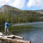
Climb gently through woods to meet the lake outlet where the creek falls and pools beside you.
Just over three miles from your starting point, land your prize as you top out at Leslie Lake. Last stocked in July 2019 with 1,000 westslope cutthroat trout, the 12-acre waterbody at 8,380 feet sits 1,000 feet below Crow Peak.
If it’s the peak you want, the shore’s surrounding ridge intercepts views of the summit. But the lake may curb your yearning for higher conquest. Yellow blooms of groundsel by September fringe the outlet beside a campsite with views west of the ridge’s shapely shoulder. The rest of the wooded shoreline is walkable around the east including a brief surge over a low promontory. In a quarter mile, the lake’s inlet rambles out of the head of Queen Gulch, braiding toward a shaded campsite near grass flats along the north shore. A tenth of a mile across the inlet, a steep track disappears up into trees.
If Crow is still calling, this is where you climb, past the Elkhorn Skyline Mine.
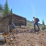
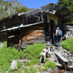
Elkhorn Skyline Mine
There are two routes to reach the mine, tapped mainly for its gold-bearing ore, now a collection of abandoned structures perched around 8,400 feet in a glacial cirque at the head of Queen Gulch. Choose either route as an out-and-back, or hike up one and round down the other to close a loop from the jeep road that includes both the mine and Leslie Lake.
The first option climbs from Leslie Lake, just west of the inlet on the north shore. The overgrown road sheering up into trees is not as intimidating as it looks. Elusive at times, it flattens through whitebark pine along the headwaters of Queen Gulch. In a quarter mile, a sunken cabin overcome by downed trees, easy to overlook on your right, marks a shift: Curve right and climb strategically through water coursing down the trail to gain the lower mine site. Narrow-gauge rails arc out of a caved portal. A rocky road curves up to the main site with a rundown but serviceable cabin, a lean-to, an outhouse, and a collapsed vertical shaft, half a mile from Leslie Lake.
The second, more direct route to the mine stays the course along the jeep road and offers vistas inaccessible from the lake. Stay straight on the road without visiting Leslie Lake. Bypass the Leslie Lake junction about 2.5 miles from your vehicle. Within a quarter mile, meadows open alongside you as the grade eases and the rocky footing relents. Cruise past a midsummer flare of wildflowers with views right and back of the Boulder Valley curving down past the Bull Mountains toward the Tobacco Root range. About 3 miles from your starting point, the road hairpins left around a notable switchback. Valley panoramas haze out south and east toward the Madison and Gallatin ranges and across the Bridger mountains.
Enticed by your only glimpse of Crow Peak en route to its threshold, continue straight along the road past the obscure Glenwood Lake trailhead branching right in about a mile. At about the 4.5-mile mark, the road curves down to the mine.
Glenwood Lake Trailhead
About four miles from your starting point along the jeep road, past the Leslie Lake trailhead and the panoramic switchback, a vague junction with an obscure sign branches right. Ascend the faint footpath that flattens then climbs through whitebark pine and whortleberry. In about half a mile, the trail planes out along the ridgetop above 8,800 feet. The ridgetop marks a reckoning, offering options that may test your capabilities.
The first, easiest route continues on trail to drop into Tizer Basin. Watch for low, enigmatic cairns as the path fades across talus then steals back through trees. Fractured rock faces draw you down a steepening footpath through forest toward distant vistas. About 2.75 miles from the Glenwood Lake Trailhead, meet a motorized trail lined with towering cairns at the Ballard Mine. You are over seven miles from your vehicle. Junctions beyond the Ballard Mine link to Tizer Lakes, Little Tizer Creek, Manley Park, and Poe Park.
Two additional route alternatives from the ridgetop require advanced skill. Judge your navigational confidence through trackless territory and your competence on sheer, hazardous terrain.
The second option drops you into Glenwood Lake, hidden from view by an abrupt pitch but stocked with westslope cutthroat trout at 8,266 feet, over 500 feet below the ridge. There is no trail. Chance the difficulty of dense deadfall down precipitous slopes with loose talus more skiable than hikeable to bottom out on the shore.
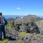
A third option delivers you to Crow Peak, about 600 feet above the ridge. If you have hiked up from Leslie Lake, you have yet to spy the apex. May anticipation feed your urge to climb.
Crow Peak
To mount Crow Peak requires dead-reckoning through trees with no trail and no sightline of the summit.
Leave Glenwood Lake Trail along the ridgetop and proceed west through whitebark pine. Take stock of your location; you must chart the same blind path back to the trail. Climb gently in general. The generous ridge holds you on course, rounding down then dropping off on either side.
Hummocks of whortleberry thin out over talus. As the canopy of stunted trunks opens onto a plateau of rock knobs, you still have no view of the peak. Pick your way over talus cloaked with blooming mats in July. If you can climb higher, you’re not there yet.
One mile after leaving the trail along the ridgetop, skirt a final knob and behold Crow Peak, highest point in the Elkhorn Range. Crowned with a flag. Staring you in the face. Whether you have snuck up on the summit or the summit has snuck up on you, the climax may seem anticlimactic. But scramble up the rock, feel the wind as the mountains fall away: Elkhorn Peak, the Boulder Valley, the outlets draining Tizer Basin, foothills shallowing to flatlands, ranges trailing the horizon, the land billowing out to blue distance. You’ve won your mountain high.
On your descent, don’t let tired feet get the best of you. Mind your footing over loose rock down the jeep road back to your vehicle.
Vaia Errett is one of seven volunteers serving on the Jefferson County Parks, Trails and Recreation Commission, an advisory group to the Board of Commissioners. Send comments to ptrc@jeffersoncounty-mt.gov or visit www.jeffersoncounty-mt.gov/trails.html.
Directions
From Boulder, follow Highway 69 south for seven miles and turn left at the Elkhorn sign onto White Bridge Lane. Cross the Boulder River and turn right onto Lower Valley Road. Bear left at about two miles onto Elkhorn Road, transitioning to dirt. Turn sharply left again at three miles to stay on Elkhorn Road. Continue eight miles to Elkhorn. Keep left through town for 0.4 miles then curve right to a sign at the T-junction straight ahead. Two-wheel drive is not recommended beyond here. Take a right at the T-junction toward the cemetery for 0.4 miles, curving sharply left uphill and continuing left down Tramway Road (sign says Designated Route). Drop gently for 1.5 miles on a very narrow road with stretches of exposure and few safe places to turn. Park before the creek at the junction with Queen Gulch, with space limited to 2-3 vehicles.
Distance
To Leslie Lake: 3.25 miles one-way
To Elkhorn Skyline Mine: 4.0 miles one-way passing Leslie Lake; 4.5 miles one-way along jeep road;
To Glenwood Lake Trailhead: 4.5 miles one-way passing Leslie Lake; 4.0 miles one-way along jeep road
To Crow Peak: 6.0 miles one-way passing Leslie Lake; 5.5 miles one-way along jeep road
Net Elevation Gain
1,900 ft to Leslie Lake
1,950 ft to Elkhorn Skyline Mine
2,100 ft to Glenwood Lake Trailhead
2,400 ft to ridge above Glenwood Lake, with steep 500-foot drop to lake
Net Elevation Gain
1,900 ft to Leslie Lake
1,950 ft to Elkhorn Skyline Mine
2,100 ft to Glenwood Lake Trailhead
2,400 ft to ridge above Glenwood Lake, with steep 500-foot drop to lake
3,000 ft to Crow Peak

